07 May 2024

Illustrated Physical Geography on North America, ca. 1920

4138

Back in 1920 they employed skillful cartographers with definite artistic skills to create illustrative maps with beautiful physical form.


We return to the 1920 geography book we picked up at the Gethsemane Rummage Sale last Saturday. 

This is very lively to the eye. The green of the plains is evocative; the western cordillera stands out proudly, the ice-covered areas give a chill.

It's gorgeous not just as a map, but simply as art.

04 May 2024

How Addresses Developed in Salem, Oregon: A Thumbnail Sketch

4137

Thanks to a dear friend from my distant past and current future, today I stumbled on something I didn't know I wanted to know but actually did want to know.

Now, when it comes to Address Nerdery I'll take second place to few. I have literally obsessed about the way Portland grew its house number system since I was a child and long before I lived here permanently; something about the quadranted house number system suggested more than a basic level of design and my mission was, for myself, to find the reasoning, at least for myself. Then I ran into Eugene E. Snyder's book which Explained It All and a handful of kindred spirits in the online world who looked at things the way I did. I now know much more than I ever thought I'd know about Portland's address system but also a whole number of towns and cities.

And that's as maybe. But I was born of the Salem and Silverton area and I seem to have stumbled into exploring about that. And my friend tossed me a link that opened a little bit of history like a flower that I didn't know I was looking for.

See, unlike Portland, Salem was always just Salem; it didn't start out as four cities in a trench coat that had to co-ordinate street naming because otherwise it would be a crazy-quilt. Salem didn't even abut any other town until Keizer decided to stop messing around and organize as one back in the 1970s. But it did grow an address system, as it turns out, and it changed at least once.

The basic information was gleaned from a post at the Willamette Heritage Center's website at https://www.willametteheritage.org/house-numbering-address-ordinances/. And, I guess I hadn't found it myself because this only exists on the 'web since 2021. But it lays out a simple though interesting time line.

  • 1885: Salem City Ordinance 151 defines the address system with 40 numbers per block. Addresses increase northward from Leslie Street (runs east-west, one block north of today's Mission Street) and eastward from Water Street (runs north-south along the Willamette River bank). Addresses did not exceed 560 on streets paralelling the river (the north city limits at the time ran along Mill Creek) and went up as far as 280 on the east-west streets as far east as where the State Capitol is today. 
  • 1904: Salem City Ordinance 436 sets up the house number pattern used today though does not establish address directional suffixes: West Salem would not be added to the City of Salem until 1949 and Salem itself was limited to the east side of the river only. Streets did have directional prefixes, but only if they crossed a baseline. It was at this time, that State Street became the principal division between north and south Salem addresses, and the house number allocation per block was adjusted from 40 to 100.
  • 1957: The system established by the 1904 ordinance served until this time, but it was decided by 1957 that the city had grown enough to require grown-up address districts. It was at this time that the N/NE/SE/S/NW districts were established and deemed to be directional suffixes.

The media coverage of the day was very practical, even bland, which kind of fits for Salem. On Sunday, Oct 13th 1957, the Oregon Statesman ran a very modest article on page 30 about it with a somewhat-crabbily drawn map to illustrate:


 Some of the nomenclature is a little bewildering: Triangle Area, I must admit, leaves me a bit baffled, unless they were commenting on the general shape of the N and S districts. Some of the descriptions have not sustained: while the text seems to suggest that River Road North will be suffixed NE it is suffixed N, and Liberty Road was supposed to get a SE suffix it got S, but both roads are indeed the boundaries as otherwise stated. 

The one essential area that Salem lacks, SW, is only referenced as "a small stretch between the river and the NW area". The 100-block baseline to NW is basically a line formed by Edgewater Street NW and Hwy 22 going west from the core West Salem area. The only area that reasonably describes is Polk County south of Hwy 22 and west of Eola Bend, where the Willamette meets the highway. There has never been any residential development of any scale in that area, and west of that area, while the house number pattern is continued the street naming conventions are not; NW pretty much peters out at the Hwy 22/Hwy 51 intersection. So while there is room for SW as the pattern scales out, I doubt there will ever be a metropolitan Salem address that ends that way.

One other thing I was able to find was this article in the Oregon Statesman published the very next day:

The "oh, well, best get with it" attitude of the article is a scream, quite frankly. Suffixes are now with us, learn to like it, pal. Eventually we'll get used to it. 

And SW is but little populated as yet? Oh, 1957, you had such high hopes for us.

Ex Libris, Marian Frances Milne, of Portland, 1920

4136

before I delve into this 1920 geography and its aged delights, I wanted to show you all what I found in the inside front cover and also the front endpaper.

The owner and location of the book lovingly inscribed thereupon is what appears to be a light green ink in classic penmanship of the day:


The script parses as follows:

Marian Frances Milne
1317 E. 12th St North
Corner of Holman
Portland ore

Telephone: Walnut-1279

 The addressing would seem quite nonsensical to a modern-day Portlander, but as I've pointed out, long long ago, the address system in Portland was quite different before the 1930s. Today, an address on NE 12th Avenue at Holman would be in the 6300s, and the expression of the street name would be much different: East 12th Street North reflects its location north of Burnside and on the east side of the river, but in those days, numbered streets outside of downtown were prefixed east and suffixed north if they were north of the Burnside baseline. The comparative small magnitude of the house number came from that there were only 20 house numbers to the block in those days.

But whether or not you grok how Portland laid out its house numbering prior to the Great Renaming of 1933, the careful penmanship is actually rather heartbreakingly beautiful. One can picture the nib varying the flow of ink with pressure. 

Truly, art.

The New Geography, 1920

4135

Here's us, and by us I mean we in the USA, in the year 1920, and how we trained our schoolchildren to look out upon the burgeoning, opening-up new world and planet.

I found this book at the world-famous Gethsemane Lutheran Church's annual rummage sale, which was held today from 9:00 AM to 4:00 PM, with similar hours tomorrow as well.

And the book you look upon here was published in 1920, or at least copyrighted as such and I'm going to assume that it was published then as well, which would make this artifact 104 years old. And it's held up rather well.

I haven't read all the text, so I don't know if the Columbian Expeditionary Force is specifically mentioned, but it does come from that point of view. Places in it just becoming known to the dominant culture of the audience of the time were deemed 'unexplored' or 'discovered' by some historically-famous European. 

But if nothing sends that message, certainly Columbus' fleet as the cover illustration does. What a historical gem this is. 

I have several pictures of this codex that I'm going to share along with my usual droll, dry commentary, so a good time is ensured to be had by all. Buckle up.


The View From Steelhammer Road

4134

Up on Steelhammer Road, on the east side of Silverton, is the house I grew up in for most of my childhood in Silverton, which is at the south end of Steelhammer, just before it goes through a curve where it becomes Evans Valley Road.

That's all I'll say of it for now; the building still stands and is a private residence, and the property has been most lovingly and sumptuously treated. I took a few pictures, but I'll be keeping them to myself. But this, looking north on Steelhammer at its intersection with Reserve Street, is something sharable.

It's been more than a couple of decades since I saw this bit of road on a regular basis. Now, with the perspective age provides, here are a couple things I know now:

  • The road was named for a family whose last notable relation ran a pharmacy on East Main between Water and First, next to the restaurant we then called The Towne House. My trauma-riddled memory kicked that back out when I saw a photo taken of East Main during the 1960's (it was probably Gus Frederick's fault I saw the photo, for which I'm grateful).
  • On the horizon there you can see the shoulder of a butte-like hill. That's Mount Angel, the hill (as opposed to Mount Angel, the town, which is to the left and obscured by trees there). When I was a lad, I didn't realize that I could see the Benedictine Abbey from just a block away from my then-abode.
  • Seeing this view point explains to me, and I didn't really realize it until I was last-year years old, why views like this transfix me so. There's a subtle thing about elevation and atmospheric perspective that makes the hills of eastern Marion County have a certain ineffable sparkle to them. The view across the rolling hills out near Shaw and along the Silver Falls Highway east of that are magical and otherworldly to me.
  • One thing that hasn't changed is that the house that was at one time my home is still literally immediately outside of town. When I was small, the city line hugged the side of Steelhammer to Reserve and turned west again there. Today, the city limits go south to include the HOA neighborhood that fills the once brush-and-brambled gully just west of here south along East View Lane, but it executes a do-si-do around the property that is my eastwhile residence. Plus ça change, plus c'est la même chose, as them Frenchies say.


30 April 2024

Amongst The Willamette Archipelago

4133

The highway along the Cascade Piedmont, Hwy 213, sometimes has a surreal aesthetic to it. I mean, the highway winds along side the hills and looks out over the farmland of the eastern Willamette Valley and the feeling is nothing so much as being in a speedboat on a peculiar sea, dotted with islands.


There'll be large stretches of flat tilled land with a massif in the distance that's really an island of trees rising from the generations-tilled flatland.

There's a vague feeling of otherworldliness to the landscape there.

29 April 2024

You Can Almost Hear The Train Whistle

4132

On South Water, in Silverton, at the end of the park that centers on the Library, there's a building that looks quite a bit like an old railroad depot.

That's because it is an old railroad depot. When I was a lad, this building stood on North Water on the north side of the train tracks. Even when I was a kid, though, the era of passenger train service had come and gone, and the building was just used as storage by then. Some time during the 1970s, some enterprising group moved it about half a mile south on Water Street, to where it is now. 

And it's now a museum of local history, because if there's one thing Silverton knows, it's her history

The signage is preserved on the gables of the the building.


The picture depict the end of the building that points toward Silver Creek. The end of the building that fronts on Water Street will tell you that Portland is 47 miles away. Which it is, more or less, though since the building's not where it once was, some negligible error has been introduced.

The idea of a passenger train connecting Silverton to The World Outside is so damned romantic, though. This is why people think they'd be happier born in an earlier era, or at least one reason. My experience as a child in Silverton was that the place, despite its nearness to Salem, was pretty isolated. It would have felt different if we'd had rail service, though. 


The Words of the East Portland Prophets are Written On Freeway Overpasses

4131

They have to be. We still don't have subways here in Smug Transit Town, USA.

Seen some months ago, westbound on Division at the I-205 overpass:


Here's a poet, who knows it.

As much as I fancy someone out there knows something we don't, I think the reality is they're saying something we all instinctively know but can't necessarily connect. But we will one day or another, one supposes.

28 April 2024

Margaret Plumb Paints the Wolf Building En Plein Air

4130

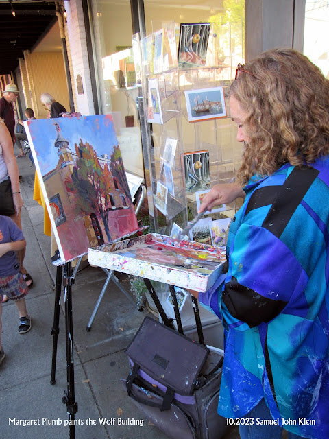
Sherman, set the Wayback Machine for that warm fall afternoon last year, when we larked to Silverton and stumbled into the Sidewak Shindig. We met Gary Quay there, and that was excellent in and of itself, but I did find this example if en plein air art in action and the memory still warms the heart.

It should be developing now that the Wolf Building in downtown Silverton is unique and beloved. It makes a fine subject for photography, and that I've proven. But plein air acrylic painting? Well, there could, I suppose, be a question, but really, if one has any common sense, that question should pretty much answer itself.

And if it doesn't, consider this:


The artist is a woman from the Eugene area named Margaret Plumb and what has become a fond memory is her allowing me, a still-aspiring artist, to look over her shoulder while she created this work. 

She's an impressionist, working in saturated colors which warm the eye and the heart (her Facebook page is here, her page at Lunaria Gallery, where she was standing in front of, is here). Most admirable technique and an accomplished talent. 

This one she was painting that day in front of Lunaria was sold, in short order, to a buyer in Virginia; testimony to that and the finished panting can be seen at this Facebook post. I had a great experience watching an artist create lovely art in real-time, and I'll ever be grateful to Margaret for allowing the house of Klein to invade her personal space, answer little questions about her process, and tolerate inane observations about what she did.

It can be problematic to get an artist to allow you to watch them create as they do it, so if you ever get the chance, savor this. Nothing quite like it, I can guarantee you. 

15 April 2024

It's All Eyes on 162nd

4129

There's much murally goodness at 162nd and Stark. Those adventurous enough to venture round back of the 76 Station at the corner can also have a look at a community-oriented mural.

The mural is titled The Eyes of All, and is credited to ATS and "Rosewood", which is the name of the community improvement non-profit centered in the neighborhood. It was created in 2012, making it 12 years old, and it's in splendid shape for being out there as long as that.

It's a colorful, cheerful tableau of a vibrant community that just happens to also be populated by a whole bunch of one-eyed creatures as well. 

So, magical realism? 

Whatever it is, they got their eyes on you. Don't try anything funny.


The Sign at the Village Square

4128

Village Square is a shopping center at the corner of SE 162nd and Stark, where Portland meets Gresham. It was probably built some time in the 1960s, judging by the architecture; the original tenants, whomever they were, have moved on, the current tenants being somewhat typical of the area: the centerpiece is a Latino supermercado, Su Casa; there's a church on one end, and the other end has a smoke shop, a social-service non-profit, and a tavern.

The sign is still vintage and proud of it. 


It does kind of show its age though. This is the side facing east, which I chose because it still has all the vintage letterforms. Several are missing from the western face.

11 April 2024

Silverton's Crows' Nest

4127

Even if you're in a town as modestly-sized as My Little Town of Silverton, you might miss something if you don't look up when you would otherwise be looking down, or sideways, or whatever.

Now, I will cop to a bit of disingenuity here. As we are finding out about one of The Most Oregon Places That Ever Existed, Silverton has enough architectural quirkitude and charm for a town many times its size; that's what happens when you let the old buildings stay and don't break your neck trying to remake the place in a fashionable mode (yes, Eugene Field School is no longer there, but that was a sad necessity). Indeed, Silverton's architectural vicissitudes are east to spot ... but sometimes, you do have to trouble yourself to take a moment and look up

The facade of the Palace Theatre, with its Art Deco detail comes immediately to mind, but a half-block south of that, on the same side of North Water Street, there's, this:


Stand in front of Mac's Place, turn south, and look up, and there is this enigmatic cupola perched on the northwest corner of the Wolf Building, which I've mentioned before, just a few articles ago.

Now, I was born in Silverton, and lived there until my early teens. And I knew the Wolf Building, remembered Hande Hardware and its wood floors. I was borne of ancestors who had lived in the area since the 19th Century. I guess I knew Silverton about well as any kid would, but it wasn't until I was an adult that I knew that crows' nest even existed. 

And now I'm hungry for a look out those windows. And I know of no other town that can claim a weather vane on the peak of the tallest building in town, but there it is. Silverton, you never stop surprising even this jaded former resident. 

It's true; Silverton contains enough architectural wonder of more than one Silverton, but the Wolf Building contains enough design interest for one Silverton, one Molalla, a Gervais and about half a Scotts Mills.


08 April 2024

They're Building a New Library in Gresham

4126

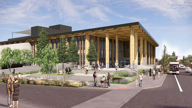
At the corner of NW Division St and Eastman Parkway in Gresham, a new library is going up. Multnomah County Library is growing like a weed (a weed of knowledge, yo) and Gresham is lucky to host a huge new branch.


They've started and they have the crane in, as can be seen. When completed, in 2026, it'll be more than just a branch, but an east-side flagship; nearly as big as the Central Library. 

From the page about the project at https://multcolib.org/building-libraries-together/east-county-library:


Completion date: Mid-2026. Be there or be severely uninformed.

07 April 2024

It's an Art Trading Card Exchange at I've Been Framed

4125

Something I tucked toward the end of the post, two back, about IBF and our new M'Reptunian friend is something that deserves to be broken out on it's ownsome, so here I go with that.

Artist Trading Cards are a delightful thing, and in this era of existential dread about AI ruining art for artists who want to make their livings in it and just make it a commodity, ATCs are just the tonic we need to remind us that art is a personal thing and a human thing and can still not only be an industry but also a personally liberating thing.

There is literally nothing wrong with ATCs. They're small, 2.5 by 3.5 inch (64 mm by 89 mm), the same size as a sports trading card. You put some art on it, your own stuff, simple or complex, whatever moved you. You meet other artists. You trade cards.

Seriously, that's all there is to it. Simple, honest, elevated, personal. Democratic? You bet. Literally anyone who likes to art can do this; they can't keep you out.

They've been around for a bit. They were started in 1997 by a Swiss artist, name of M. Vänçi Stirnemann, at his second-hand book shop in Zuerich. They've been a presence ever since, a low-stakes way of doing and sharing art with a highly emotional payoff. Better info you can find at the Wikipedia page

Here's how you can get in on the conspiracy (they aren't all sinister and evil) and have some fun too:


In June, I've Been Framed Art Supply Center is staging a gallery show. If you get an ATC to them before the 15th of May, you'll be included in the ATC swap after that show. Basic details are available in this photo I've inserted above, or, hey, how about going to IBF at 4950 SE Foster Road some time and ask them about it? They'll tell you all you need to know and send you off with an ATC blank to do your bit on, and you return it to them. No money required, they just do this because IBF is a revolutionary place that way (small quiet revolutions are just as important as the big noisy ones). Pick up a pencil or a brush or a little paint while you're at it, you're on the way.

And you're doing it just the way the founder did, back in Zuerich in '97. 

There is literally no reason not to do this, all else being equal. 

Division Street at the Portland City Line

4124

Back on the outer east side of Portland, as Portland as you can go because the Gresham city line is literally at my back here, at SE 174th Avenue and Division Street, looking west.


This is another example of my poor-man's telephoto, which mostly involves a long sightline and a tight zoom ... but I've always liked the result.

Of interest, off on the horizon, is a hill called Kelly Butte. If you're down Division at about 101st and look south off Division, that's the hill you'll see there; yet another notable member of the Boring Volcanic Field, which is the constellation of nobbly hills starting at Mount Tabor and straggling out into Clackamas County until it merges into the Cascade foothills.

Kelly Butte has a place in Portland Civil Defense and cinematic history, because from 1955 through about 1974, the bunker there hosted Portland's emergency Civil Defense nerve center, to which city officials would rush in the event of a Soviet nuclear attack. In 1957, CBS broadcast a movie titled The Day Called X, a documentary narraated by actor Glenn Ford, dramatizing Portland's response to a notional Soviet bomber assault (this was in the days before ICBMs, when nukes came delivered Dr. Strangelove-style, from the bellies of big planes and the city had time to get out of the way), and that bunker - staffed in the film by people who were really Portland city officials at the time, including Mayor Terry Schrunk - was a key location in the film. In 1974, the bunker became the 911 headquarters for the Bureau of Emergency Communications, and in 1994, the bunker was decommissioned and sealed when 911 moved to a more modern location.

Kelly Butte's current job is holding a lot of Portland's drinking water in underground tanks that once went to the now-decorative reserviors at the foot of Mount Tabor, near SE 60th and Division. 

There was also a legendary honky-tonk out this way, the Division Street Corral, also known as the "D Street"; a legendary venue, it hosted acts from John Mayall to Johnny Cash and Paul Revere and the Raiders. 

The page as https://pnwbands.com/divisionstreetcorral.html, has a pretty complete list of all the musical goodness that passed out that way, and some of the pictures are still up (some have died due to net rot). 

One other thing to note is the wiggliness of what would seem on paper to be a rather straight road, and that's another reason I enjoy creating these pictures. Surveying was precise but I guess sometimes it was never perfect, and drawing straight lines on a sphere, which strikes me as one of surveying's great challenges, introduces quirks of its own. 

It also makes pictures like this look nifty. 


The Path of The Eclipse, Via Google Maps: An Experiment You Can Try

4123

Recently I saw a map tracing out the anticipated path of this weekend's solar eclipse across the eastern USA using bookings from AirBNB has a guide and I remembered there was another way to mark it, but it won't work until just as and after the eclipse happened.

As detailed in a blog post I made on the 23rd of August, 2017, you can see the effect on traffic if you turn on the Traffic layer on Google Maps and zoom it properly. I did, that day (after being inspired by a Facebook observation Mike Selvaggio made), and this was the result:


This comes from the fact that, despite entreaties from various local and state DOTs to the contrary, people are going to clog the roads going into the path of totality and create multi-hour traffic jams that ought to be reflected on Google Maps. As it can be seen from my own mapping above, the path it picks out is pretty faithful.

Was it really seven years ago? Damn. Tempus is fugiting all over the dam' place. 

The M'Reptunians Walk Amongst Us, And Other Things At I've Been Framed On Foster

4122

This is why I've Been Framed is a place one cannot do without. Not only it it just a great place with revolutionary artistic energy, but you meet extraterrestrials.

The extraterrestrial was in her full camouflage as a terribly charming 7-year old young woman possessed of a firey, fierce creativity. I will explain.

We wanted to stop by this. our favorite art place and the best one in the world, because Spouse was looking for pink fluff for cat toys. Our youngest feline, Tabitha, loves fluff toys, but she's very particular. They must be a specific shade of pink. And she's annihilated the ones we had for her and finding that pink, which seemed quite common, is proving unexpectedly, uncommonly difficult to do. 

Prairie thought she might be of help, so off we went. 

Once we were there, I wandered about looking at art supplies while Spouse's attentions were more directed. Chatted with Prairie, which is always a pleasure. She showed me a bottle of linseed oil which is part of her extensive collection of vintage art supplies. I should have gotten a picture of this ... it had to be from the 1940s or so, it had the label of a downtown Portland pharmacy that had a phone number that a named exchange (CEdar, I think it was). And the vintage bottle was gorgeous and the contents still looked okay, though I think one has to go beyond mere looks when it comes to eighty-year-old linseed oil.

It was at that point I crossed paths with the young lady from M'Reptune. She was engaged in animated extemporaneous discourse with Prairie, who had moved down to that end of the room by then. This small brown-haired force of nature was there with an older woman we'll presume for the moment was posing as this incredible being's mother; their down jackets - properly pillowy in PNW construction - had identcal colors. And she had so much to tell us about her treks and travels. 

At first it was not revealed that she was extraterrestrial; her first representation was that she was technically a cat. She then demonstrated moves that suspiciously echoed the chaotic interaction our cat Ralph had with the belt on the fuzzy pink robe we kept on the bed for the itty bitty kitty committed to make biscuits on, so her claim actually has come credence.

She then clued us in on the M'Reptunian connection after that, while letting us know enroute that she was technically also a squirrel. 

It was impossible not to be entertained by her banter, and I'm not kidding, it was non-stop, on fire but unconsumed. Tiny TED talks about the amazing culture and technology of M'Reptune reeled out of this young woman's imagination at a rate of knots, tales of her hyperspatial travel (it takes her two milliseconds to go from here to M'Reptune, for what that's worth) and I just bathed in this tiny delightful sun of instant creativity. So much unafraid, unabashed exposition, such joy in telling us of her worldbuilding, I couldn't help but smile and just listen. 

There is a quote variously attributed to Beaudelair and Rimbaud, that goes "Genius is the recovery of childhood at will". I've always had the rational grasp of that, but here, displayed in front of me, unfiltered and unabashed, was that childhood that those of us who strive for creativity seek to capture. Most all of us had periods in our childhoods where we had these daft kid-ideas that we played with, created stories with, made drawings and paintings. I've for years, in the way of Proust, tried to get it back. Now that I've seen it up close with someone who couldn't help but share it, maybe it'll be a little easier to find.

As for our alien interlocutor, she left the shop about the time me and Spouse did, but as she left she gave me a gift, asked me if I wanted of her technology, and into my hand she dropped a M'Reptunian ray gun. 

It's mine now, this M'Rretunian ray gun, given freely, and nobody can take it away. 

It's unlikely, but I hope I remain the world long enough to see what direction she takes that fabulous ball of happiness in. They might stop by IBF again, who knows?

That drove back some shadows on my brow, and I tell you no lies there.

For me, what did I get? Feast your eyes.


It's a vintage Grumbacher Gainsborough oil paint box. When originally sold it carried 24 tubes of Grumbacher Gainsborough oil paint in the two middle compartments, painting accessories in the long compartments left and right, and brushes across the bottom, at least I think that's the way it works. And it'll carry some art accoutrements for me, I just have to figure out which ones and why. 

Also! I've Been Framed Art Supply Center is holding a showing in June and an Artist Trading Card swap at the end of it. Anyone not familiar what ATCs are and why they're nifty, well, Google that stuff, or even better, stop in IBF's Art Supply Center at Foster and Powell and ask 'em about it. They'll fork over a single blank ATC media - either smooth or textured, a little 2.5" x 3.5" card and you go wild and drop it by and at the end of the showing we all swap 

ATCs are a fun, low-stakes way of dipping a toe into the grassroots art world. All sorts of media happen, acrylic, mixed media, oils, watercolors, and the lot, but I personally find it's a great pairing for drawing and cartooning. However, it's all great fun and the trading cards one gets out it are decidedly delightful and the very definition of unique.

IBF's Art Supply Center is located where it always has been, 4950 SE Foster Road, here in Portland. It's a one-of-a-kind place, Prairie is our hero, and anyone reading this owes it to themselves to stop by.

06 April 2024

The Wolf Building, The Antique Heart of Silverton

4121

I've picted this building before, but it was a Creative-Commons pict. This one is copyright mine, mine, ALL MINE. 

Adolf Wolf is another one of Silverton's small gods. Silverton's city center is loaded with historic architecture and the more I think about it, the more this building must be considered one of Silverton's crown jewels that way. It has immaculate cast iron detail (which I enthused about here). It was erected in 1891 which, I think, makes it the oldest extant building in Silverton:

I remember it as a boy for Carl Hande Hardware, continuing the mercantile tradition Wolf started and marketing implements to the little farming metropolis Silverton was at the time. Of course, just like every charming old building in Oregon currently, there's a bisro there, so there's that.

The biggest charm in this image is the lovingly-preserved painted ad on the Water Street side there. 

And I might be a little sarcastic about it all, but if I wanted to open some creative concern and brand it with Silverton's charm and quirk, I'd certainly consider the second floor of that building. 

The Covered Pedestrian Bridge, Silverton

4120

In the last missive (and maybe one or two previous) I made mention of the pedestrian bridge that connects Town Square Park, next to downtown Silverton and across the creek, to Water Street at Lewis. 

Illustrated here is the bridge if you aren't on it taking pictures:


The covered bridge is something personal to Silverton; one of the most historic covered bridges in the state, the Gallonhouse Bridge, is located about two miles north of here, just outside of town (follow First Street to Hobart Road, left on Hobart to Gallonhouse Road, and right on Gallonhouse to the Bridge itself, as we will do sometime soon). So this charming little bridge, which makes it all of a piece.

The Gallonhouse Bridge was named for what people would trade at that point, during Prohibition years. The nature of the substance traded in gallons is an exercise left to the reader, but I'm sure I've left enough clues that the reader can intuit it.

The trade may have involved an ancestor; my mother liked to tell me one of the things my grandfather, the first Samuel John Klein, did, was hide 'shine on his dairy farm, which was located northeast of town about halfway between Silverton and Scotts Mills.

It's a family legend which will have to stay that way, because of reasons. But it's a fun story to hint at.

04 April 2024

Town Square Park, Silverton, and My History Thereupon

4119

As mentioned in the last posting, there is a park in the middle of Silverton now, along West Main, between the bridge and Fiske Street, which is terribly charming and comfortable, and they call it Town Square Park.

It's roughly square in shape and goes back some 100-150 feet from West Main. If one goes to the south side of it, and looks north from the ramp to the covered footbridge, just past the war memorial, the view one gets approximates the picture, thenceforth and herewith.


This is a patch of ground I have intimate history with. I'll explain.

In the middle background, in front of that brick building (which at one time was the local phone company building and probably still is telco propertry, though not in the way it was when I was young), is a length of West Main Street that runs about 160 feet in length, give or take fifteen feet or so. And along that brief bit of road, if you drove west from the bridge, there were the following three buildings on that side of the street in this order:

  1. A building that looked as though it once provided services to cars which, even in my youth, looked dusty and disused for decades
  2. Hoyt's Grocery
  3. A gas station on the corner of Fiske that started out as Hancock and later was a Fina station.
Hoyt's Grocery remains a treasured, if attenuating, memory. My mother worked there for a few months while I was a toddler and we were rooming with my Grandma Klein on South Second in the months before we moved up to, and I commenced my formative years on, Steelhammer Road. And many times during that childhood we stopped in for this and than at Hoyt's.

It was the old-school kind of small market, unlike today's quick-shops, c-stores, and roadside markets: it was stocked with dry goods, a small selection of produce and meat, and essentials that you could stop for on the way home if you didn't feel like going over to Roth's or the Safeway. I mean, we knew the owners. They were sweet people. I remember old Lillian Hoyt, how she was just this sweet old lady who ran the grocery store with the assistance of her family, how she lived in the apartment in the small triplex that was tucked in behind that gas station on the corner. I remember how the sign over the front of the store had HOYT'S GROCERY in big, chunky, curvily voluptuous letters, the way that sign was bracketed by two big 7UP (I think it was 7UP, anyway) signs, and the way the front wall was actually set on a track and could be opened like a closet door if they had to. I remember the wooden floor of the place.

And now here am I, wandering through this park and there's no trace of those places. I hope pictures of the old grocery store exist somewhere. I'd like to see them again. 

And now here am I, wandering through this park and in spaces that I couldn't have walked to when I was small, and thinking about how we think as we grow aged the world moves on without us and we can think that way if we want, but we can also think that things change and the world does move on but it moves on with us as passengers and the views from the ride are actually quite lovely, if we accept what we see. 

Getting too philosophical means I've maundered a bit too prolix, and I should leave this here. 

And that I shall. 

The Back Stairs To Silver Creek

4118

We return to Silverton to get to know Silver Creek a little better. It's changed and gotten incredibly charming, and deserves the tarry.


Along West Main Street, just the other side of the creek from the center of town and Water and Main, is a park, Town Square Park. Quite a lovely place and with it I'm rather smitten. It is roughly square in shape, fronting West Main between the end of the bridge and Fiske Street, with a small parking lot at the corner and a charming public toilet (Portland has its Loos, but leave it to Silverton to make a public convenience charming), and at the south side of the park, the pedestrian path winds past a war memorial to cross a covered footbridge over Silver Creek that'll connect you back to Water Street a block south of Main.

If you stand on the bridge ... which has ample room for those who want to take it slow and absorb the charm ... and look upstream, in the general southward direction, you see this, a property on Fiske Street backing up to the creek itself and this stairway from that property going right down to the creek bank which is all so adorable I say, without trace of irony, that I can't even here.

It has occurred to me that the owner of that property is quite the fortunate person. 

It, and the presence of Riverfront Park in Salem, speak of a quantum leap in how Valley communities relate to the streams that flow through them. In Salem, as I said earlier, downtown ended for most of us at Commercial Street, Front Street was a railway-laced nightmare for your car's chassis, and riverfront access for downtown Salem was the veriest of oxymoronic things to say. Silverton's relationship with Silver Creek was similar though not as brutal; an unbroken line of buildings along the west side of Water Street made the creek a thing you glanced in passing over the bridge.

No longer. Silver Creek is still screened from downtown Silverton by the buildings but there are more and more personal ways to get closer, and Town Square Park, a lovely thing, which allows one to come right down to the side of the stream that inspired Silverton's name. 

03 April 2024

Rest in Power, Dabney Spring

4117

There's a spot on Historic Columbia River Highway, just a few seconds east of the entry to Dabney State Park, along the Sandy River, and just before Neilsen Road forks off and goes up the hill, on the north side of the road.

One year ago, it looked like this:


That stream of water coming out of the pipe in the cement block was termed a spring by people who visited on a constant basis. Now, HCRH is not a wide road and there is literally no safe shoulder there. During dark winter months when I was coming home essentially at night one had to take great care, and especially when it was a heavy rain, there were great opportunities to hydroplane.

During the autumn of last year, though, the Oregon Dept of Transportation and Oregon Parks and Recreation called an end to the free water party. In these days where everything has an electronic constituency, roadside springs do, too, and there was great discussion about it on Find A Spring, at https://findaspring.org/spring/locations/north-america/usa/troutdalespringdale-by-dabney-troutdale-oregon/. There was a lot of dismay in evidence, people upset over it, blaming City of Troutdale and that, but a correspondent posting as Michelle S laid this upon us:

ODOT and the Oregon Parks and Recreation Department have decommissioned the reservoir overflow pipe along the Historic Columbia River Highway near Dabney State Recreation Area because of increasing road safety concerns at the site.

The area has become a danger with motorists stopping, often partially blocking the travel lane, to fill water jugs. The drainage ditch is often blocked by illegal dumping of material and damaged by vehicle traffic, which causes water to overflow onto the highway and creates dangerous driving conditions.

Oregon Department of Transportation and Oregon Parks and Recreation Department posted signs and shared the pending plan with the Northeast Multnomah County Community Association before decommissioning the overflow, which is located along the north side of the Historic Columbia River Highway near Dabney State Recreation Area, east of the Stark Street Bridge.

The pipe originally supplied water to cool car radiators at the time of the Historic Highway’s construction over 100 years ago and was one of a handful of similar water access points, most of which have already been decommissioned. The water that supplies the pipe was not intended as drinking water.

ODOT and OPRD will evaluate the feasibility of creating safer access in the future.

ODOT has already seen crashes at the site and is taking this step to help ensure there are no more.

The nearest publicly available free water can be found 3.2 miles north along the Historic Columbia River Highway at Lewis and Clark State Recreation Site.

Coming up a year later, you can see that they were serious about it. Here's what it looks like now ...


Pipes are gone, and the one that dispensed the water has been sawed off to the level of the block. 


The concrete baffle blocks are all gone, and the sign spells it out plainly.


Don't tell the officer you didn't see the sign.

Now, one will notice that there is water flowing in the roadside ditch. It's not coming from here; it seems to be seeping out of the hillside by the intersection of Nielsen Road about 100 feet east from there. 

Maybe there is some sort of spring. Still, the idea of a series of water cooling stations for early automobiles has a certain logic to it.

Anyone going out that way will notice a few signs up on telephone poles along the road:


It's a real thing, they also have a website, https://www.restoredabneyspring.org/. It's one of those pre-desgined, out-of-the-box websites, and it's kind of tasteful, actually. but there's been no further change in the status of this roadside water port, so I'm guessing they aren't getting very far in their efforts, or at least not yet.

I mean, never say never, but I think the likelihood of Dabney Spring returning is vanishingly small. 

Sic transit gloria mundi.

02 April 2024

Perhaps, a Memorial

4116

This face, giving off vibes of manga, are on the door side of the storage container that has Barney Rubble on:


This face is enigmatic and somewhat forlorn. It floats in a cloudy sky. The look on the face is passing a vague despair. The ear gauge is peace sign; the caption forever speaks of wishes and memory. And there's a halo up there in the upper right corner.

A memorial, perhaps? A forlorn wish for a better world? Both ... or some other deeper meaning? 

This Is Not The Barney You're Looking For

4115

Stark Street is a great source of street art. You have to know where to find it though.

The intersection of 162nd and SE Stark St sits at the place where Portland leaves off and Gresham picks up. There's a shopping center there, Village Square, which is a vintage edge-of-town suburban shopping center built back when this was the edge of town and suburban.

At the corner is a 76 Station, and alongside that station is a container used as storage. It has be gloriously decorated with joie de vivre. And a Flintstone character.


It's a little bit of a surprise, actually. You think Barney and what comes to mind is a purple dinosaur which used to be ubiqutious on public television, not the second banana to Fred Flintstone.

So, for letting ol' Barney Rubble be the star of the show/ Nothing but respect here from me. Actually, I liked the character of Barney better than Fred. He seemed to be a little bit smarter, in his way. 

01 April 2024

The Center Street Bridge, Salem

4114

Salem's Bridges, like Salem itself, are contradictory.

They're essential, but unremarkable. They're crucial, but you don't think about 'em much. There's nothing preposessing about them, but you'd miss 'em if they were gone.

Salem, depending on the year, is either the Oregon's Second City or Oregon's Third City: after Eugene holding a slim lead for the greater part of my life, they've been one or two thousand apart and swap the position once every couple of years. Right now, I think Salem's number two. And for a city as big as it is now, with only two bridges linking the two halves ... well, that's just kind of absurd.

If you want to go from the eastern half of Salem to the western half, you have to go through downtown. And if you're going to the west side, you're just as likely to be bypassing west Salem as you are likely to be destined there. It comes from the two sides' shared history, of course: founded in 1913, West Salem, Oregon was city of its own until it merged with Salem to form the kernel of the present-day town.

They needed infrastructure work and didn't have the money, is the story I always heard.

So, West Salem, before it was merely west Salem, was a suburban destination. 


And to this day, there's only one way into West Salem, and one way out. The bridge pictured is the way out. West of here, State Hwy 22 forms a very brief riverfront expressway bypassing the West Salem business district, Edgewater Street NW, before dividing, in a manner shared by Albany and Corvallis, into two main city center streets. This bridge feeds Center Street NE. 

It's a muscular bridge, as is its older sister, the Marion Street Bridge, immedately north. Has to be: it's not only the only way across the river for miles in either direction, but it's the main highway west out of Salem in toto. And, unlike our Portland bridges, it just does its job without calling attention to itself.

Pretty much like Salem itself. State capital, political power center of the state, but outside of the Capitol Mall ... it's just this Oregon town. 

31 March 2024

Historic Houses on the Salem Waterfront

4113

Waterfront Salem is a vastly different place from what it was when I was growing up. In the mid-1970s Front Street served an what amounted to an industrial area and was laced with disused railroad tracks. 

I wasn't even aware there was a Water Street, which is the closest street Salem has to the river, until the 80s. And even then it wasn't clear how one would get down there.

What a difference forty years makes. Not only is it a simple thing to get down to what is now a lush and inviting public space, but there's lovely interesting things to see there. Following Union Street NE one block west of Front, you bear left at the old steel bridge that used to carry a rail line across the river and is now a very nice pedestrian bridge connecting the east bank riverfront to Wallace Marine Park in west Salem. 

Between the Marion and Center Street bridges, along Water Street, is a big Victorian house which today is devoted to housing the Gilbert House Childrens' Museum. Along side of it is two other historic houses which is part of the Childrens' Museum complex.


The addresses are 450 Water St NE (on the left) and 440 Water St NE (on the right). I did bump the color up on this photo, because being adjacent to the main Gilbert House itself, I had storybook illustrations playing about in my head.

This angle, looking back the way we came, shows the Gilbert House itself, green amongst the tree.


Cheerful, charming, historic Salem. 

Oh, and it bears mentioning that the Gilbert who the Gilbert House represents is A.C. Gilbert, the man who, through his efforts, gave the world one of the landmark toys of the 20th Century ... the Erector Set. Yeah. Like the guy who gave the world the View Master, A.C. Gilbert, too, was an Oregonian.

The Height of the Eastside Street Art Renaissance, feat. Suspish

4112

Last August, the brief renaissance of outer east Portlandia street art hit something of a zenith, most of it on the west wall of the building that the Portland Police Bureau's Sunshine Division - which is the PPB's charity public engagement arm - which is located just east of SE 122nd Ave on Stark St.

The west wall has no windows and faces onto the north parking lot of what was once was the Fabric Depot store, and is without a doubt, a honeypot no tagger can resist for long. So, when Suspish showed up on the east side again (the second appearance by the Eugene artist) it was plain that something was going to happen.

So: dateline, east of 122nd on Stark, August, 2023. We have this:

Now, I'm not necessarily a fan of graffiti either, and if you do it in Portland, in some areas, you take your life into your hands. So, if you're going to bring it, bring it memorably. Make it good, make it skillful, make it art. And our various artists who gave us this gallery-in-passing did just that.

First thing, we have on the far left here, is this:

... a big ol' blue-white-black tag, something of a signature, with FOE, East, and '23 and 2023 in various places. This took a little care and design forethought and engages the eye nicely.

Next we have ...


... another appearance from our friend Suspish. The Suspish fish is obvious; the abstract Cylopean face colored in a dusky mustard yellow is also Suspish's work, I believe. 

The mouse is some other artist's work, a johnny-come-lately to the gallery and while inspired and whimsical doesn't quite show the skill that Suspish and this next artist shows.

Speaking of the next artist, here we are:


The original work in this gallery, which I think I've posted about when it first showed up. These two were the first on the building a few months before, and the creativity and artistic skill here still delight my eye. To the credit of the Sunshine Division, they let this stand for a number of months before covering it over, and a lot of us eastbound Stark Street drivers got to enjoy them. 

I particularly adore the intensity of the dude with the spray cans. Chef's kiss here for that.

Again, the signature EAST FOE can be seen by the ear of the figure with the spray cans, so I think it was the same artist that did the big tag on the far left.

To close our gallery tour, this:


SWOOP. Another boi with a hat, and signed again, apparently, by FOE. 

The building has since been painted, and the west wall of the Sunshine Division's building hs returned to that industrial vaguely-oatmealy color. Graffiti - street art - has an expiration date. No matter how skillful it is, it's designed to leave us, as the property owner always has the last word.

Most of it is just lazy marks, but some of it, sometimes, gets really elevated. I hope Suspish comes up this way again eventually, and another visit or two from F.O.E. would not be amiss. 

They brought their A game here, and I was, curiously, happy to see it. 

30 March 2024

Salem, We Need To Talk About State Street

4111

Salem, you need to get a grip. You got lots of problems. You might run out of money. That's bad. You might close your public library. That's appalling.

But this ...

Explain, I will.

Now, Salem has directional addresses as anyone who's ever heard me drone on about city maps and street layouts and address systems will, after all this, have by now known. And especially if you live there. And it works like this: If you're on the east side of the Willamette River but north of State St, you're NE. And if you're on the east side of the River and south of State St, you're SE. But if you're on State Street, you're neither NE or SE; it's the dividing line. Also, there's no State Street on the west side of the river, so there's no State St W, therefore, no State St E. 

It's just State St. It always was State St. 

Now, just west of Cordon Road NE, which is where town ends (both the unincorporated fringe and the city limits, where they come out that far) and on the north side of State, for years, there was a field, going up to a rail siding that ran parallel to State, and a locally-famous mushroom production facility. I lived on Abiqua Ct SE, just off State via 47th Ave SE, during some formative years during my teens, and we all knew about it

You know what mushrooms grow in. The smell got around.

Well, in the decades since, the mushroom plant has gone, and the rail line with it, and at long last the area along the west side of Cordon Road NE going north from State Street in the direction of Auburn Road is finally being filled in with a housing tract. New streets going in, new houses going up, little old Snailem inching its population ever closer to 200,000. Some of the street blades have already gone up. and here's one sharked from Google Street View:


State St NE, the sign says. And this is wrong, Salem, and you know it.

Why is that a problem, you might ask? Wouldn't the north side of State Street be NE? Well, like I said before, State Street is neither NE nor SE, and it's not E because there's no W half. Besides, most blades along State St just look like this:


This is 47th Ave SE and State, just a few blocks west of that (this corner is in unincorporated Marion County, which has shifted to a street blade format nearly identical to that used within Salem city limits over the years). Just State St. Just like it always has been.

Like eliminating the leading-zero district here in Portland and making it S, labelling State St as NE or SE depending on which side of the street you're on fixes a problem that doesn't really exist and erases a charming local address custom. 

Now, Salem, I know you're short of money and all, so all you have to to is stick a piece of green over that NE there. 

But however you do it, get a grip here.

I say this because I care.

The author is available as a highly-opinionated consultant on designing street naming and address systems due to his obsession of it over the course of more than four decades. Contact for rates.

28 March 2024

Toes of the Mountains

4110

The course of Oregon State Highway 213, a road which technically begins at PDX and goes to Salem, dances along what I've come to think of as the Cascade Piedmont.

Anyone reading this probably understands that the word piedmont, literally translated, means 'foot of the mountains'. There's a region in the deep South that they call 'piedmont', the fall line where streams in Dixie emerge from the foothills of the Appalachians and spread out across the plains on their way to the Atlantic Ocean.

 The Cascade Piedmont I am terribly fond of is nowhere near as extensive but I think just as remarkable.


Highway 213 dances in and out of the toes of the Piedmont quite nimbly. Much of the time, as you close on and go south of Molalla in the direction of Silverton, it's obvious ... to your left, the land is notably hilly, on the right it flattens out and gives great views of wide and deep farmlands stretch to the distance-diminished Coast Range thirty or forty miles west.

And when it comes to a hill, it skirts around its middle.

Despite the fact I've called Portland home for more years in my life than anywhere else, I still feel a strong connection to this ground, this particular soil. It's emotional, but real; I was born along the Cascade Piedmont, and I have a father and a brother who are buried in its ground. 

Much the way a young duck is said to imprint on the first face it sees as a parent, I must have done same with this ground.

Nothing like it anywhere else. I guarantee this.

27 March 2024

The Church at Second and A

4109

The subtraction of the century-old Eugene Field School building from the landscape of city-center Silverton has opened up sight lines that young me never even comprehended existed.

If you look grid-east and a s'kosh north from the corner of Park and Water Streets, the lack of a rather substantial building opens a line of sight two city blocks long.


The big white historic-looking building, which is the Trinity Lutheran Church, is at the corner of N. 2nd and A Streets. Google Maps says this is at a range of about six-hundred and thirty feet from Yours Truly, the photographer. N. 1st Street crosses the middleground at where that chain link fence is. The red brick building wit the multi-colored windows is the First Christian Church. The green space in the foreground is the lawn on the south end of the new Civic Center block.

When it comes to church in Silverton, if you want it, you got it. More church than you can shake a steeple at.

In looking around the town of my youth, I'm amazed at how wide my perception of the world has become. These places are mere minutes away in a walk, but since I couldn't directly see them when I was young, they may as well have been halfway around the world. Perspective widens with the altitude of age; it opens the world at the same time drawing it closer in.

Escher would approve of that, I think.